
File:Downtown Pittsburgh from Duquesne Incline in the morning.jpg
From Coder Merlin

Size of this preview: 800 × 534 pixels. Other resolutions: 320 × 214 pixels | 640 × 427 pixels | 1,024 × 684 pixels | 1,280 × 855 pixels | 2,560 × 1,709 pixels | 6,741 × 4,501 pixels.
Original file (6,741 × 4,501 pixels, file size: 27.33 MB, MIME type: image/jpeg)
Summary
| Description |
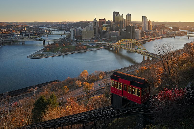
English: This is a classic composition viewed from the observation deck on at the top station of the Duquesne Incline in Pittsburgh. The Duquesne Incline is one of two surviving inclines in Pittsburgh, the other being the Monongahela Incline.
Español: Vista desde la plataforma de observación de la estación superior del funicular de Duquesne en Pittsburgh, Estados Unidos. El funicular de Duquesne y el de Monogahela son los últimos dos funiculares operativos en Pittsburgh.
Polski: Widok z tarasu widokowego na górnej stacji kolejki Duquesne (ang. Duquesne Incline) w Pittsburghu, w stanie Pensylwania, w USA. Kolejka Duquesne jest jedną z dwóch kolejek linowo-terenowych w Pittsburghu, które przetrwały do naszych czasów. Drugą jest kolejka Monongahela (ang. Monongahela Incline).
Українська: Вид на місто з оглядового майданчика на верхній станції фунікулеру Дюкейн в місті Піттсбург, Пенсильванія, США. Це один з двух фунікулерів в місті, іншим є фунікулер Мононгахіла. |
| Date | Taken on 20 November 2015, 07:37:49 |
| Source | Own work |
| Author | Dllu |
| Other versions |
Numerous photos from the same vantage point have been taken. |

.jpg)


| Camera location | | View this and other nearby images on: OpenStreetMap |
|---|
Assessment
This image was selected as picture of the day on Wikimedia Commons for 20 November 2017. It was captioned as follows: English: A view from the observation deck at the top station of the Duquesne Incline in Pittsburgh, Pennsylvania, USA. The Duquesne Incline is one of two surviving inclines in Pittsburgh, the other being the Monongahela Incline. Other languages:
Čeština: Pohled na střed města Pittsburgh (Pensylvánie) z vyhlídky u nejvyšší stanice doposud funkční lanové dráhy Duquesne Incline. English: A view from the observation deck at the top station of the Duquesne Incline in Pittsburgh, Pennsylvania, USA. The Duquesne Incline is one of two surviving inclines in Pittsburgh, the other being the Monongahela Incline. Español: Vista desde la plataforma de observación de la estación superior del funicular de Duquesne en Pittsburgh, Pensilvania, Estados Unidos. El funicular de Duquesne y el de Monogahela son los últimos dos funiculares operativos en Pittsburgh. Magyar: Kilátás a Duquesne Incline felső állomásán található kilátóból (Pittsburgh, Pennsylvania, USA) Nederlands: Uitzicht vanaf het observatieplatform van het bovenste station van de Duquesne Incline, een kabelspoorweg in de Amerikaanse stad Pittsburgh Polski: Widok z tarasu widokowego na górnej stacji kolejki Duquesne (ang. Duquesne Incline) w Pittsburghu, w stanie Pensylwania, w USA. Kolejka Duquesne jest jedną z dwóch kolejek linowo-terenowych w Pittsburghu, które przetrwały do naszych czasów. Drugą jest kolejka Monongahela (ang. Monongahela Incline). Português: Vista a partir da plataforma de observação da estação superior do funicular de Duquesne em Pittsburgh, Pensilvânia, Estados Unidos. Українська: Вид на місто з оглядового майданчика на верхній станції фунікулеру Дюкейн в місті Піттсбург, Пенсильванія, США. Це один з двух фунікулерів в місті, іншим є фунікулер Мононгахіла. 한국어: 미국 펜실베이니아 주 피츠버그 뒤켄 강삭철도 꼭대기 역의 전망대에서 바라본 풍경. 뒤켄 강삭철도는 피츠버그에 남아 있는 두 개의 강삭철도 중 하나로, 나머지 하나는 모노가헬라 강삭철도이다. 中文: 图为一只位于肯尼亚奈瓦沙湖的雌性大鱼狗,它利用树桩打断这条尼罗口孵非鲫的脊椎,以便将其吞下。 |
|
Licensing
I, the copyright holder of this work, hereby publish it under the following license:
This file is licensed under the Creative Commons Attribution-Share Alike 4.0 International license.
- You are free:
- to share – to copy, distribute and transmit the work
- to remix – to adapt the work
- Under the following conditions:
- attribution – You must give appropriate credit, provide a link to the license, and indicate if changes were made. You may do so in any reasonable manner, but not in any way that suggests the licensor endorses you or your use.
- share alike – If you remix, transform, or build upon the material, you must distribute your contributions under the same or compatible license as the original.
File history
Click on a date/time to view the file as it appeared at that time.
| Date/Time | Thumbnail | Dimensions | User | Comment | |
|---|---|---|---|---|---|
| current | 13:24, 23 February 2016 | | 6,741 × 4,501 (27.33 MB) | wikimediacommons>Dllu | less denoising, less graduated neutral density filter, slightly warmer white balance |
File usage
The following page uses this file: